AI-powered geospatial data processing, fully on-premise. Commercial software connecting large language models with QGIS, GRASS GIS and GDAL – controlled through natural language, with complete data sovereignty. Available in two editions, 30-day free trial.
Spatial Agents are a middleware and integration layer connecting large language models (LLMs) with professional GIS tools. The software itself contains no AI – it orchestrates external models via API keys that you provide yourself (BYOK: Bring Your Own Key).
A GIS professional opens QGIS Desktop, types a natural-language request into the chat panel, and the AI assistant orchestrates the work: it calls MCP tools to download OpenStreetMap data, fetch satellite imagery from Planetary Computer, run GRASS GIS terrain analysis, load results into QGIS, and apply styling.
70 tests. 37 MCP tools. All passed.
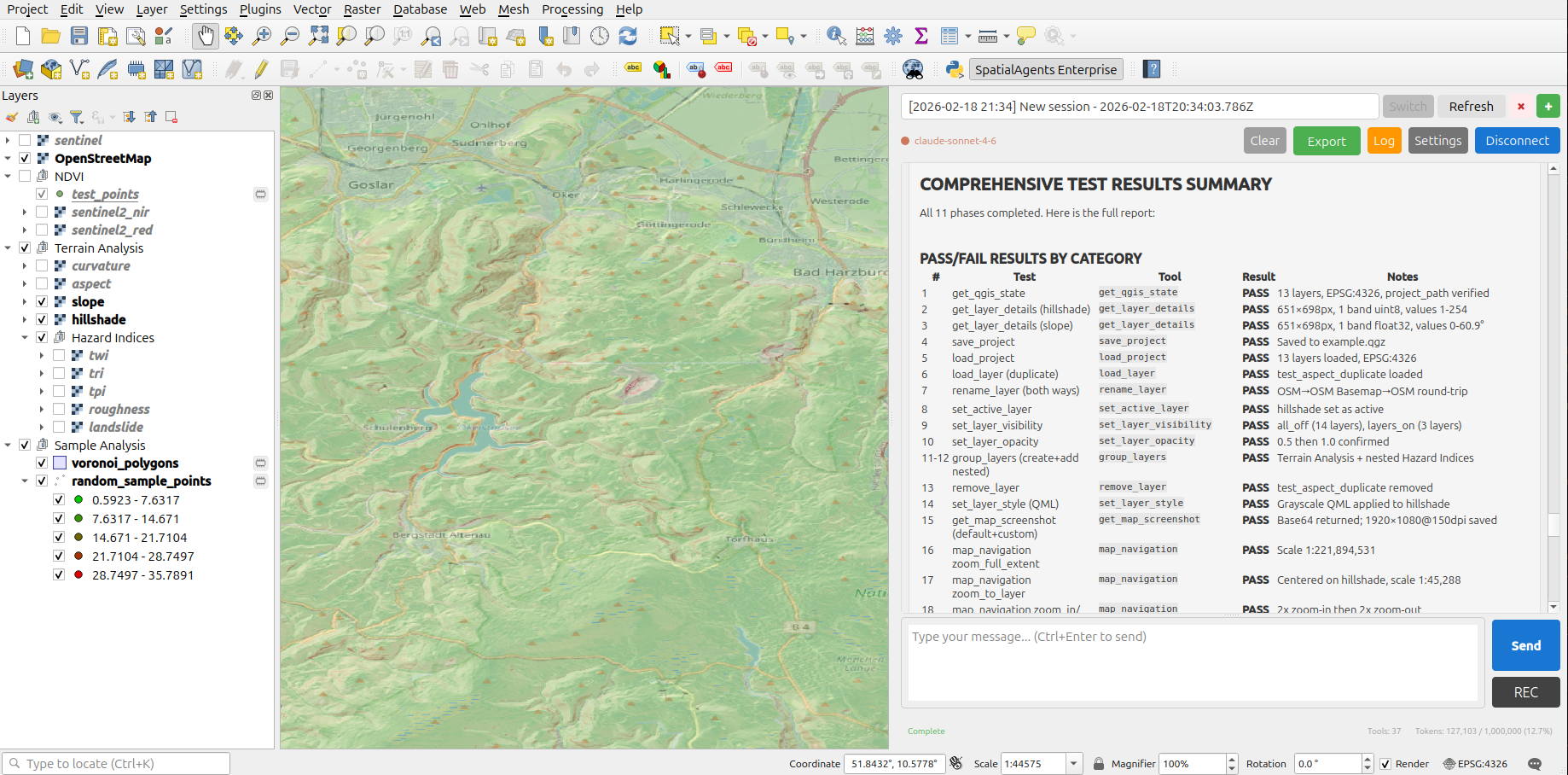
QGIS Desktop with SpatialAgents Enterprise Plugin: Full test results after 11 phases – 70 tests, all passed.
Claude Sonnet 4.6 takes full autonomous control of QGIS Desktop – no manual clicks, no hardcoded prompts. In a single uninterrupted session, all 37 tools of the MCP Bridge are systematically tested.
Climate adaptation planning, land use analysis and environmental monitoring with sovereign data processing. Designed for data-sensitive environments – air-gap capable, no telemetry, fully offline operable.
Automated terrain analysis, site assessments and environmental impact studies.
Network planning, infrastructure analysis and risk assessment for energy and water supply.
Reproducible geospatial analyses for climate, environmental and sustainability research. Academic pricing available.
The performance of Spatial Agents is continuously and publicly demonstrated through our SpatialAgentBench. The benchmarks run on the Enterprise edition with the full MCP server stack (QGIS, GRASS GIS, OpenStreetMap, Planetary Computer) and establish a practical reference benchmark for agentic work with GIS tools and geodata.
Each evaluated AI model must autonomously solve complex spatial tasks in the Enterprise environment – from satellite image analysis to terrain modeling to risk calculation. The results directly show which models are suitable for productive use in your GIS infrastructure. The benchmark portfolio is continuously expanded with new models and task scenarios.
Available from H2/2026 – 30-day free trial
For engineering firms and specialist departments.
For organisations with high security and compliance requirements.
30-day free trial – Both editions available for testing with full functionality.
Volume discounts from 2 seats (up to -40%). Special pricing for research and government agencies. All prices exclude VAT.
| Feature | Professional | Enterprise |
|---|---|---|
| Price | from 1,000 EUR/seat/year | from 3,000 EUR/seat/year |
| MCP Servers | ||
| QGIS Bridge (37 tools) | ✓ | ✓ |
| OSM Explore (8 tools, metadata) | ✓ | — |
| OSM MCP (9 tools, downloads) | — | ✓ |
| Planetary Computer (6 tools) | — | ✓ |
| GRASS GIS (12 tools) | — | ✓ |
| Tavily web search | — | ✓ |
| Total tools | 45 | 72+ |
| Skills & Agents | ||
| Skill categories | 4 | 9 |
| Skill files | ~1,900 | ~2,500 |
| @qgis-assistant agent | ✓ | ✓ |
| @qgis-analyzer agent (read-only) | — | ✓ |
| @osm-data-acquisition agent | — | ✓ |
| Infrastructure | ||
| Web UI + CLI + QGIS plugin | ✓ | ✓ |
| Local LLMs (Ollama, vLLM) | ✓ | ✓ |
| Free AI provider choice (BYOK) | ✓ | ✓ |
| Local data repositories (OSM, raster) | — | ✓ |
| Deployment kit | USB 64 GB | SSD 1 TB (encrypted) |
| Support | ||
| Email / ticket | 48h response time | 24h response time |
| Response time (critical) | 24h | 4h |
Your geospatial data never leaves your network.
Request a trial licence and test Professional or Enterprise with full functionality.
Get in touch